Agriculture to Airfield
A History of Middle Wallop Airfield up to 1939 - Part 2
Tithe Commutation Act
Originally, tithes were a tax which required a portion of all agricultural produce to be paid annually to the local church or clergy. By the early 18th century much of this land had passed from the clergy to the laity and it was seen as an outdated practice, and as such a more convenient monetary payment was introduced. The tithe survey was established to find out which areas were subject to tithes, who owned them, how much was payable, and to whom.
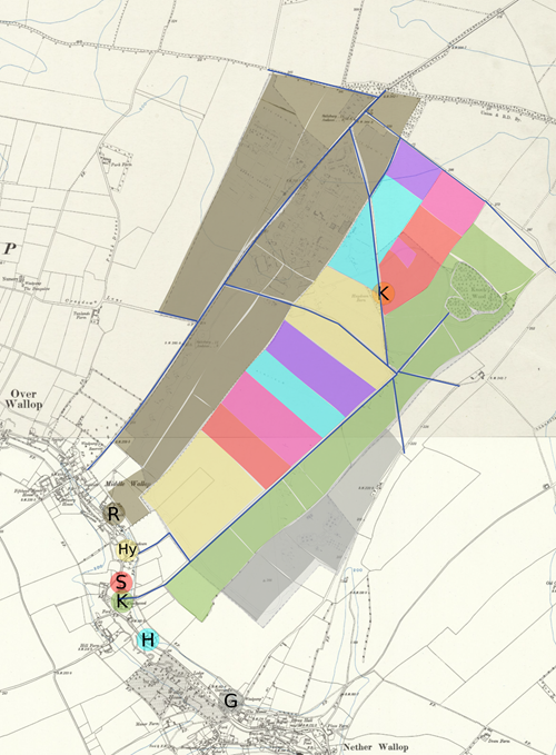
By 1840 most of the land that makes up the airfield today was held by three parties. Firstly, John Wallop, 3rd Earl of Portsmouth, who had retained all of the land held by his father at the time of enclosure and added to it (shown in green on the below map). This land remained part of Knockwood Farm and was leased to John Saunders Sr, son of James Saunders who had occupied the land previously. Secondly, William Dowling, aged 53, who owned and ran Ringwolde Farm (all the land in brown) in Over Wallop. He lived at the farm with his wife Harriet, eight children and four servants. William died in 1849 and his wife lived off the proceeds from the farm, which was run by their two sons, employing fifteen labourers and seven boys. Thirdly, Lord Bolton who owned the lands of Haydown Farm, Hatchetts Farm, Staplewood Farm, the Brownings, and Lower Living. Kentsboro Farm did not exist at this time, but Haydown Barn which would later form part of the farm did. It was owned by Lord Bolton and occupied by Stephen Webb

70% of the land above was arable land for the cultivation of crops. The rest was a combination of pasture for grazing animals, allotments, woodland, and gorse. Between 1800 and 1850 more of the land in Hampshire had been turned to plough due to the grain shortage brought on by the Napoleonic Wars.
A New Era
The 3,296 acres of land in Nether Wallop including those acres on the airfield owned by Lord Bolton (Haydown, Hatchetts, Staplewood, Brownings, and Lower Living) were sold to a London Land Agent and Solicitor, George Grant Stevenson, in 1911. He also acquired the lands of Knockwood Farm previously held by the Earl of Portsmouth. He subsequently divided all this land into several dozen plots and sold them over the next few years.
The field as it is today, open grassland, once looked very different. A sales particular from 1914/1915 shows us the types of crop being grown on the airfield, specifically the lands of Knockwood and Hatchett Farms. Sainfoin made up the largest crop, which was used as animal feed, mostly hay, to feed the heavy working horses of the period. The next abundant crop was wheat. The farms also grew peas, barley, vetches (pea family), seeds, oats, beans, roots, and rye.
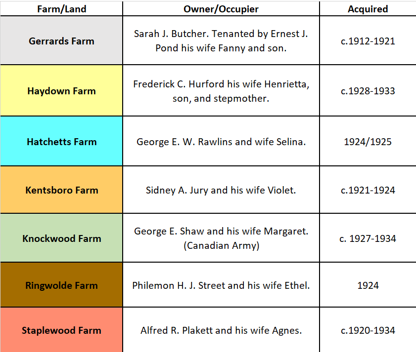
The various farms changed hands multiple times between 1912 and 1938 when the Air Ministry began acquiring land in the Wallops. Compensation was provided to the owners of the lands in the form of a lump sum. The farmhouses themselves remained with the owners (except for Kentsboro Farm), as it was the land that the Air Ministry required. However, some of the farmers decided to sell up completely and move on, rather than lose large portions of their future incomes.
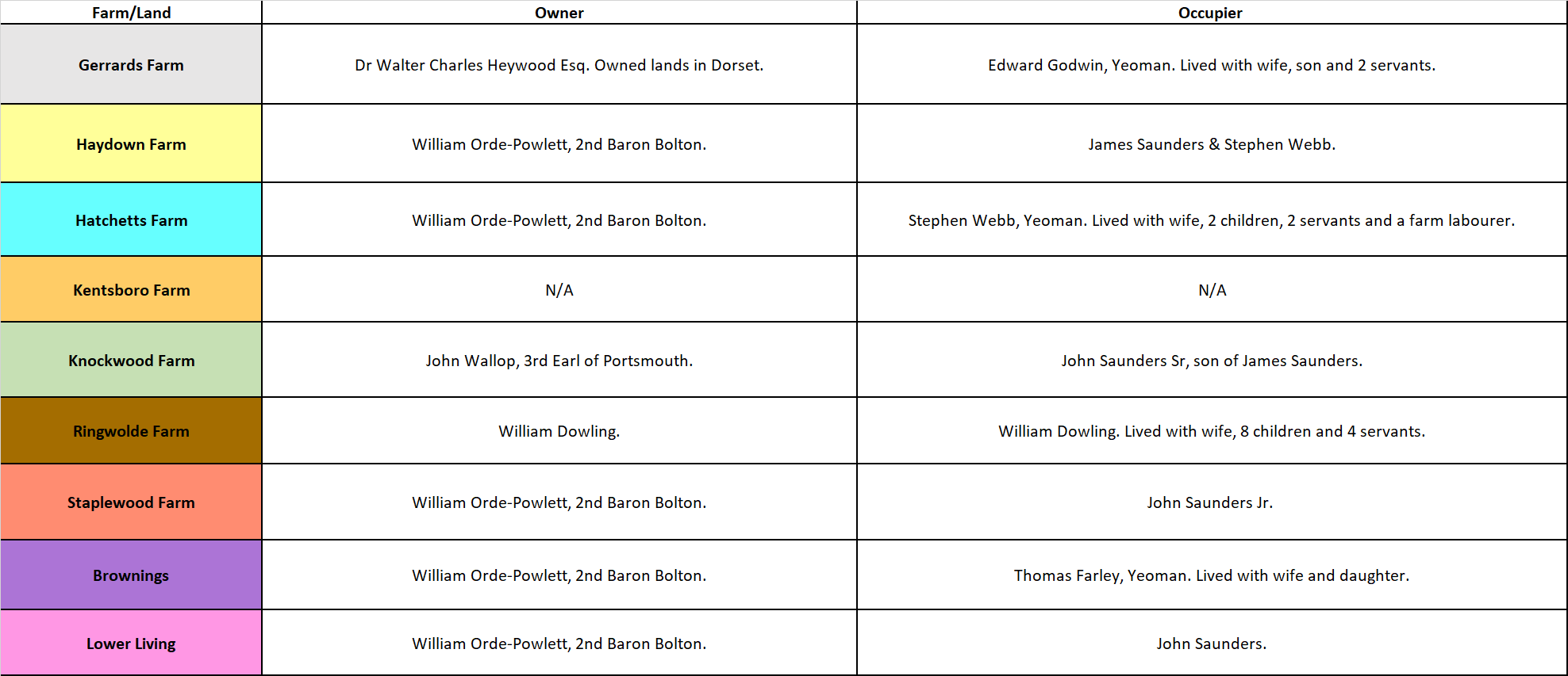
In 1937-1939 the farms were owned and held by the following:
During these years several notices appeared in the newspapers relating to the farms that held land on what is now the airfield. The greater part of Staplewood Farm was sold, including items such as, one ‘reliable’ cart horse, a herd of 22 dairy cows, and farm implements. Kentsboro Farm was only partly acquired by the Air Ministry as the rest of the farmland lay outside its area of interest. Even so, they had to sell much of the farm stock: 1,500 pullets (young hens), thousands of hens, as well as three motor cars and a motorcycle.
The 370 acres, equivalent to 210 football fields, of Ringwolde Farm, both a poultry (eggs) and dairy farm, sold its entire stock of 3,500 live poultry, the eggs, 50 cattle, calves, heifers, and ducklings. For the owner Philemon H. J. Street, however, the compensation he received from the Air Ministry was far below his estimation. He was informed in September 1937 that he may have to give up his farm. In March 1938 he told the Air Ministry the extensive profits he was making which he proved as being £2,000 a year for one hour of work a day. He originally wanted £24,000 compensation but was only awarded £13,000, more than half a million pounds in today’s money.
The story made headlines at the time with one newspaper stating:
‘Bricks and mortar for an aerodrome have already begun to imprison the soil of one of the most fertile and profitable farms in England…Giant excavators and navvies are digging up the pasture where dairy cattle grazed, so that bombers may land on level ground at 70mph’.
Mrs Watts a neighbour of Mr Street also stated that:
‘They [the men] don’t want any aerodrome-building jobs…When you see fields you have known so long disappearing, it’s like a piece of life lost’.
This opinion was not limited to Mrs Watts either. Local opinion on the construction of an Aerodrome in the Wallops was not well received. In a letter, dated October 1937, from a member of the public in Over Wallop it was stated that:
‘There is a terrible project of the Air Ministry to dump an Aerodrome almost on top of this village. It is to take all the land of Mr. Street who has built up a wonderful milk business after 5 years hard work…[it] will stretch to the back of the Wallop C[ounty] C[Council] School – We hear it is to be for “Bombers”…Even ordinary planes will be a great disturbance to the school…In the meantime we are trying to get as many protests sent in as possible.’
This was compounded in mid-1938 when the main highway, from Knockwood/Kentsboro to Middle Wallop County Council School, behind Haydown Farm was to be closed due to the airfield’s new boundaries. At a meeting of the Highways Surveyor, County, and Parish officials’ new routes were proposed. This created a few issues for the parents and children because they would now have to walk three and a quarter miles to school. Upon reaching Gerrards Farm in Nether Wallop they would travel along the footpath until arriving at the school. The alternate route was down the A343, which was dangerous, until reaching the limit of the Airfield where a footpath was constructed from the main road to the George Inn Pub by the Air Ministry (see map below). Despite the local protests and numerous letters to the council on the 7th November 1938, it was officially announced at the Castle, in Winchester, with the Country Roads and Bridges Committee, that the highway would be closed.

On the map above, you can also clearly see the original limit of the airfield site, which does not cover the same area as it does today. Sometime between 1939 and 1940 the Air Ministry increased the size of the land, meaning the highway the children were supposed to use to travel to school was now also out of use, as it cut straight across the middle of the airfield. This also meant that Sidney A. Jury of Kentsboro/Jury’s Farm would now have to give over the rest of the farm and its buildings as they were in the way of the aircraft landing. The farm consisted of a farmhouse of brick with slated roof, and a cottage of brick and flint. The main homestead (formerly Haydown Barn) had already been obtained a year prior.
The other additional lands acquired in extending the airfield belonged to Ringwold Farm, Knockwood, and Haydown. Some of the farmers remained in the farmhouses and continued to work additional lands elsewhere whilst others moved away completely. It may at the time have seemed like a ‘piece of life lost’ but it was also the start of a new life for the lands that make up todays Army Aviation Centre.
This is the end of the final part of our 'Agriculture to Airfield' blog post series. Keep checking our social media platforms for updates on when our next blog post will be released.
Bibliography:
AFM Collection
Maynard, J., Behind the Scenes: A History of Nether Wallop, (Andover: Bulpitt Print, 2011).
National Library of Scotland, Maps, [online] https://maps.nls.uk/
Victoria County History, A History of the County of Hampshire, Vol. 4, ed. W. Page, [online] https://www.british-history.ac.uk/vch/hants/vol4.
Heritage Gateway, England's historic sites and buildings, [online] https://www.heritagegateway.org.uk/gateway/default.aspx
Hampshire Archives and Local Studies, Documents Consulted:
H/CL5/1o/22, 21M65/F7/166/2, 21M65/F7/182/2, Q23/2/92/1, 97M72/DD62, 46M84/F67/7, 46M84/F67/11, 4M92/PS/77/2, H/CL7/21, 4M92/PS/77/5, 46M84/F67/5-6, Nether & Over Wallop Electoral Registers 1937-1939.
Written by Kyle Thomason, 2022